


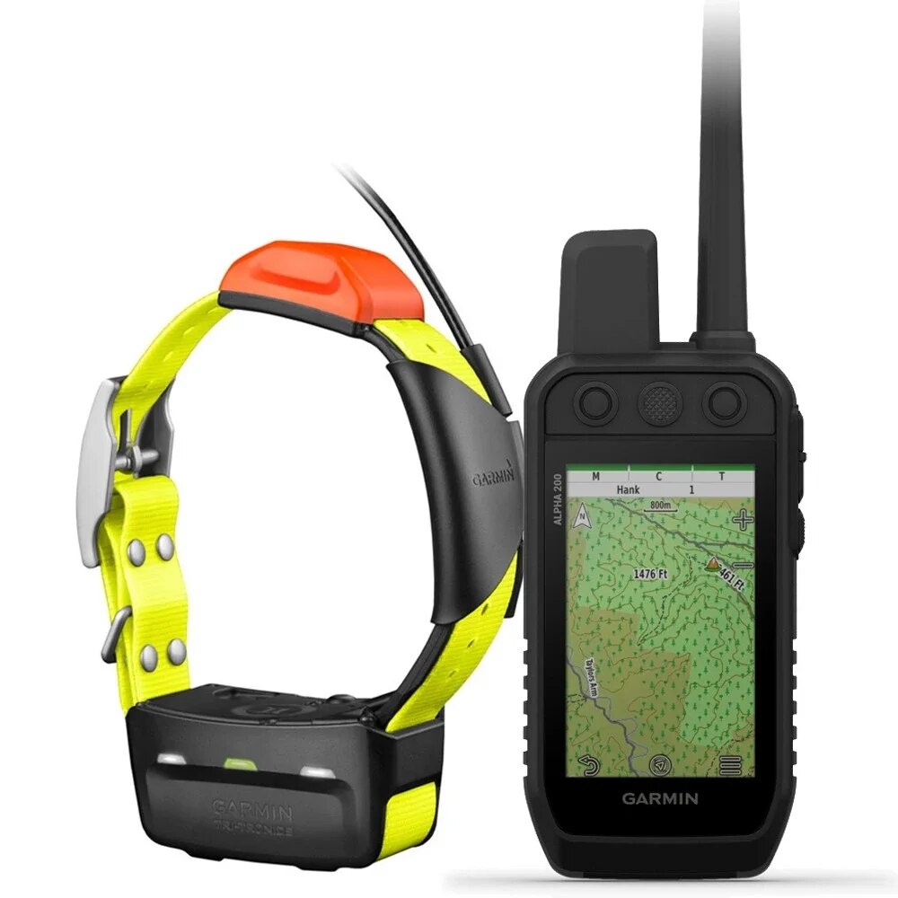
Garmin Alpha® 200i and T 5 Bundle Dog Tracker and Collar
R20,895.00
Multi-dog tracker and trainer.
 From only R2,304.19 pm over 12 months with FinChoicePay.
Find out how...
Make that purchase possible with FinChoicePay.
FinChoicePay is a new payment method that allows you to buy now and pay back your purchase over 3 to 12 months.
4 easy steps to use FinChoicePay
Browse your online stores and proceed to check-out
Choose FinChoicePay as payment method
Choose to repay over 3 to 12 months
Create your account and complete your purchase
Here's what you'll need:

A valid email address

To be over 18 years old
Still want more information on FinChoicePay? Click here...
![]() Pay over 3 EQUAL zero-interest
instalments of R6,965.00 with PayJustNow.
Pay over 3 EQUAL zero-interest
instalments of R6,965.00 with PayJustNow.
Find out how...
PayJustNow is a simple, easy-to-use payment system.
Here’s how it works:
PayJustNow allows you to pay for your purchase over 3 equal, zero interest instalments. You’ll pay one instalment at the time of purchase, the next at the beginning of the following month and the last one a month thereafter.
#zerointerest

Step 1:
Browse your favourite online stores and proceed to check-out.

Step 2:
Choose PayJustNow as your payment method.

Step 3:
Create your account as easily as if your eyes were shut (though we’d recommend you keep them open).

Step 4:
Complete your purchase and whoop for joy!
Here’s what you’ll need:
 A valid RSA ID document
To be over 18 years old
An email address
A SA Bank issued debit or credit card

Description
Track and train your dogs with the Alpha 200i system, featuring inReach® technology1, a sunlight-readable 3.50″ capacitive touchscreen and user-friendly, six-button design.
Features:
- TRACK YOUR PACK – Monitor up to 20 dogs from up to 14.50 km (depending on dog device) with a 2.50-second update rate. Pair with T 5 or T 5 mini Dog Devices (each sold separately or as a bundle).
- DOG LIST/GROUP MANAGEMENT – Keep inactive dogs in your dog list, and manage active groups so you don’t have to add and remove dogs for every hunt. Pair with T 5 or T 5 mini dog devices (each sold separately or as a bundle).
- HUNT METRICS – See each dog’s daily hunting patterns, distance and speed so you can monitor performance and help prevent overheating. Pair with T 5 or T 5 mini dog devices (each sold separately or as a bundle).
- GARMIN EXPLORE™ APP – Pair with Garmin Explore app on your compatible smartphone to see real-time dog tracking information, save collections of dog tracks and replay tracks to see exactly what happened during your hunt.
- OPTIONAL INREACH WEATHER – Use inReach connectivity to get detailed weather updates on Alpha 200i or a compatible device paired with the Garmin Explore app. Request weather forecasts for your current location, waypoints or destinations on your route.
- PRO VIEW COMPASS – The pro view compass mode gives you simple, at-a-glance tracking that shows which direction and how far away your dogs are, plus you will see when a dog is Treed or OnPoint.
- MULTI-GNSS SUPPORT – Access multiple global navigation satellite systems (GPS and Galileo) to track your pack with greater accuracy than GPS alone.
- TOPOACTIVE EUROPE MAPS – Our preloaded TopoActive Europe mapping provides detailed views of terrain contours, topographic elevations, summits, parks, coastlines, rivers, lakes and geographical points.
- BIRDSEYE DIRECT – Download BirdsEye Satellite Imagery directly to the handheld for better-than-real-life views of your route, trailheads, clearings and more.
- NAVIGATION SENSORS – A barometric altimeter helps you accurately monitor ascent and descent and see short-term trends in air pressure, and the built-in tilt-compensated three-axis electronic compass keeps your bearing — whether you’re moving or not.
- SEE IT ALL – The sunlight-readable 3.50″ capacitive touchscreen display makes it easy to see and interact with your maps, dog data and more — even while wearing gloves.
- STAY ON THE MOVE – Replaceable battery lasts up to 20 hours, or up to 15 hours with inReach technology enabled.
- ADDITIONAL MAPPING – The microSD™ card slot allows you to load more mapping options.
- TWO-WAY MESSAGING – Exchange text messages with loved ones, post to social media, or communicate inReach to inReach in the field (active satellite subscription required).
- INTERACTIVE SOS ALERTS – In case of emergency, trigger an interactive SOS message to the Garmin IERCC, a 24/7 staffed professional emergency response coordination centre (active satellite subscription required).
- LOCATION SHARING – Track your location, and share it with those at home or out in the field so they can see your progress or ping your device for your GPS location and more (active satellite subscription required).
- 100% GLOBAL IRIDIUM® SATELLITE NETWORK – Instead of relying on mobile phone coverage, now your messages, SOS alerts and tracking are transferred via the global Iridium satellite network (active satellite subscription required).
![]()
Specifications:
Physical & Performance
| Display Size | 4.7 W x 7.7 H cm; 3.5 inch diag (88.9 mm) |
| Display Resolution | 282 x 470 pixels |
| Dimension | 6.8 x 16.2 x 3.4 cm *dimensions do not include antenna |
| Interface: | High-speed USB |
| Battery type | Rechargeable lithium-ion (included) |
| Waterproof | IPX7 |
| Weight | 280 g with standard antenna and battery |
| Display Type | Transflective, colour TFT touchscreen |
| Battery life | Up to 20 hours; up to 15 hours with inReach® technology enabled |
| High-sensitivity receiver | Yes |
Maps & Navigation
| Storage and Power Capacity | microSD™ card (not included) |
| Basemap | Yes |
| Navigation Routes | 250 |
| Navigation Track Log | 20,000 points, 250 saved gpx tracks, 300 saved fit activities |
| Waypoints/favourites/locations | 10,000 |
| Memory/history | 16 GB |
| Preloaded maps | Yes (TopoActive Europe) |
| Ability to add maps | Yes |
Features
| Send route selection to MapShare during trip | Yes |
| Satellite Imagery | Yes, direct to device (no annual subscription required) |
| Connections Wireless Connectivity | Yes (Wi-Fi®, Bluetooth® and ANT+®) |
| Send waypoints to MapShare during trip | Yes |
| LiveTrack | Yes (with Garmin Explore™) |
| Exchange locations with other inReach device | Yes |
| Group management | Yes |
| Barometric altimeter | Yes |
| Interactive SOS | Yes |
| Stored contacts | 250 dogs |
| Touchscreen | Yes |
| Sun and moon information | Yes |
| Virtual keyboard for custom messaging | Yes |
| Automatic routing (turn by turn routing on roads) for outdoor activities | Yes (with optional mapping for detailed roads) |
| Range | TT 15/T 5, 14.5 kilometres; TT 15 mini/T 5 mini, 6.5 kilometres |
| Send and receive text messages to SMS and email | Yes |
| Frequency band | VHF |
| Compass | Yes (tilt-compensated 3-axis) |
| Compatible with Garmin Explore™ app | Yes |
| Tracks | Up to 20 dogs (TT 15/TT 15 mini and T5/T 5 mini) and buddies (Alpha 100 and Alpha 200i) simultaneously |
| Custom maps compatible | Yes |
| Garmin Explore website compatible | Yes |
Related Products